
The Efficient Vineyard Project
Discovering the Benefits of Digital Agriculture in Modern Grape Production
The MyEV Tool
Software for Vineyard Managers to Collect, Process, and Organize Spatial Data for their own Operation
Interested in exploring how digital agriculture technology can benefit your farm…but not sure how to get started? MyEV was developed as a free, web-based tool to help growers collect, process, and use spatial data for their own vineyard management. Log in by creating your account and start building your farm today.


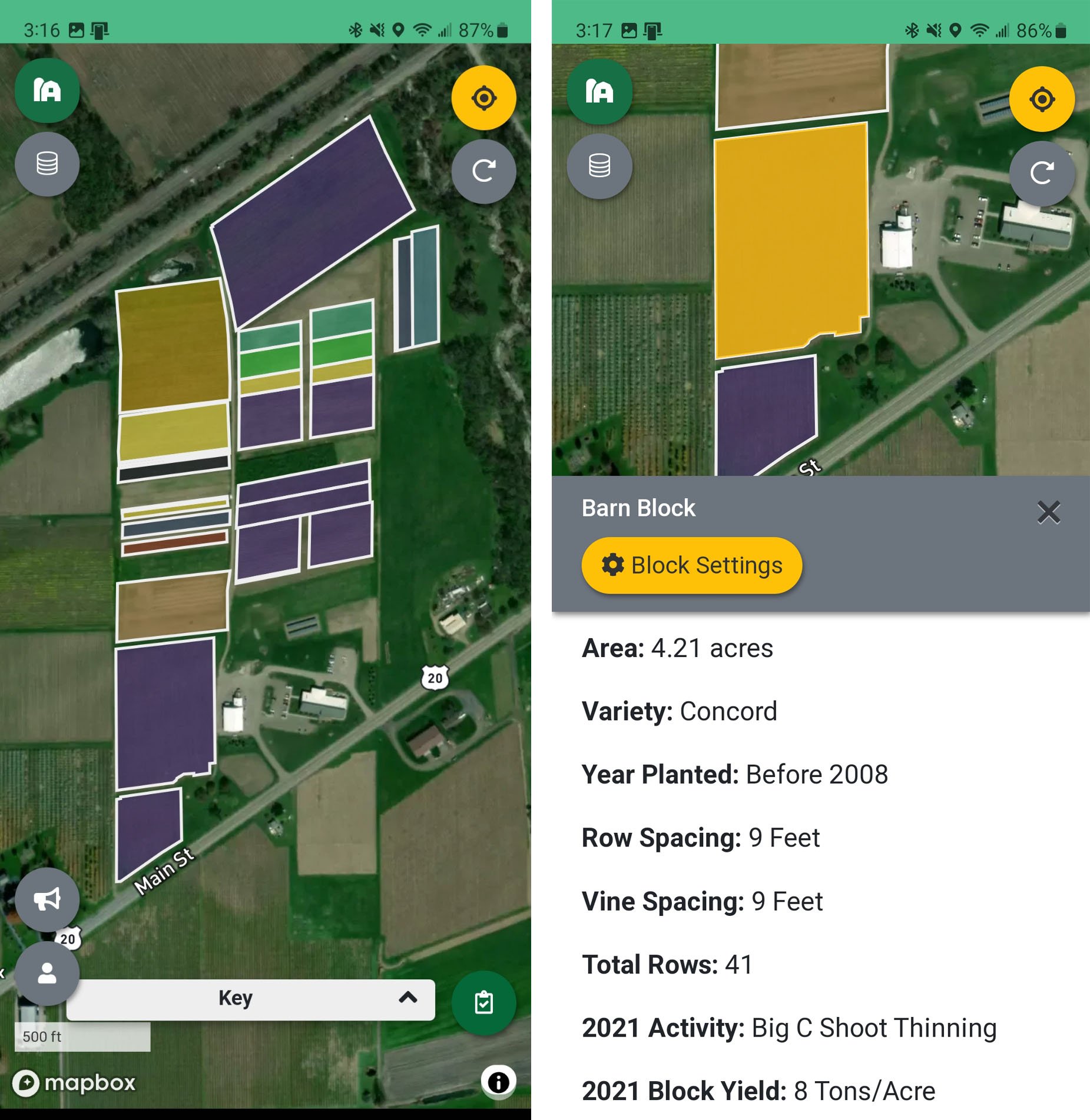
MyEV helps organize information by farms, blocks, and sub-block spatial data. Start your exploration by creating and entering information about your farm location, ownership, and preferences.
Use easy point and click tools to draw your farm blocks, add block level information, and change visualization settings.
Then identify your team collaborators and invite them to interact with your farm on their desktop or smartphone.


Start simple! Not ready to jump into new ag technology with both feet but want to easily map broken posts, gopher holes, irrigation leaks, nutrient deficiencies, virus symptoms, insect damage, or just about anything you want? Create your own mobile scouting tool with the MyEV Data Collector. Share it with your team and start mapping.

Unlock the Benefits of Spatial Data
Spatial data processing to get the most out of agricultural sensor data can be challenging. MyEV breaks data processing down into just a few easy steps so anyone can turn raw sensor datasets into meaningful viticulture information. A set of “Plug-in” tools walks you through the process.


Hit the vineyard with your favorite soil or NDVI sensor and GPS receiver to collect high-density data sets. MyEV keeps it simple by importing any spatial data with a latitude and longitude coordinate. Raster images can also be converted to point data using the Raster conversion plug-in.
No sensor…no problem. Use the customizable MyEV Data Collector and your smartphone to map your own vineyard observations.

Avoid the “garbage in garbage out” scenario of data analysis by easily cleaning up spatial data. MyEV allows you to view data clean up with simple slide filters so you keep the data you want and send the rest to the trash. Then clip your cleaned data to the vineyard block boundaries you created when you built your farm.

The power of using multiple vineyard layers to make a better management decision starts here. Data collected in the vineyard comes from different sources, densities, and geo-locations, making it difficult to compare information between layers. The MyEV Interpolator plug-in solves that challenge by processing all your data to a common vineyard grid.
Use the Data Joiner plug-in to link all of your interpolated datasets. Then just click on any grid point to display all of the information associated with that vineyard location.
Make sense of your sensor data by translating it with viticulture field measurements. Save time and effort by letting MyEV analyze the spatial data pattern and tell you where to go for field validation. Then send the measurement locations to your smartphone and share with your field team to make quick work of field scouting. Finally, compare your high-density data set with the directed field measurements for easy translation.

Turn your spatial vineyard maps into variable-rate prescriptions. MyEV lets you make the decision. Select one data layer or many data layers to generate unique prescription maps. Then export them to your smartphone to guide your farm workers or to your favorite precision ag software to control mechanical vineyard implements.
Who Are We?

MyEV is a collaboration between Cornell AgriTech viticulturist, Dr. Terry Bates, and Orbitist owner and software developer, Nick Gunner. Their teams look to integrate research based information in precision viticulture with essential data processing for a positive and productive end-user experience.

Project Support


The Efficient Vineyard Project theme evolved from the USDA-NIFA-Specialty Crop Research Initiative project, Precision Vineyard Management: Collecting and Interpreting Spatial Data for Variable Vineyard Management (Project Number: 2015-51181-24393). It continues to be supported by USDA-NIFA-Small and Medium Sized Farms Program project, Cost effective spatial data visualization and decision support for small and medium-sized vineyards (Project Number: 2022-68006-36148). MyEV is also a collaborative component to the SCRI-NIFA-SCRI Hi-Res Vineyard Nutrient Management project (Project Number: 2020-51181-32159). Key support and feedback for this project comes from the industry organized National Grape Research Alliance and its integrated production systems focus group.
Collaborators

The partnership between NASA Acres and MyEfficientVineyard (MyEV) integrates Earth observation data with multilayer information management to enhance vineyard understanding and management. This collaboration delivers actionable insights to optimize irrigation, assess disease risks, and improve yield forecasting. Together, these efforts support a data-driven approach to enhance the sustainability and resilience of grape production while boosting growers' productivity and profitability.